Author: Katie Lehman
Abstract
Tidal flooding is becoming more common in many Chesapeake Bay communities as sea level continues to rise and storm patterns change. Most coastal water-level measurements come from NOAA tide gauges, but these gauges are often spaced far apart. They may not capture flooding at a more local scale in smaller tributaries or neighborhoods. Because of this, it can be difficult to fully understand how water levels change across the region. New low-cost sensor technology makes it possible to deploy many more monitoring stations and collect higher-resolution data. Hydronet is an example of a distributed network of water-level sensors deployed in waterways across Maryland to monitor flooding and tidal changes in near real time. This paper examines how distributed sensor networks such as Hydronet can improve monitoring of tidal flooding in the Chesapeake Bay region. Specifically, it argues that distributed sensors improve coastal flood monitoring in three main ways: they increase spatial coverage in tributaries and smaller communities, support near real-time awareness of changing water levels, and provide observations that can be compared across sites to identify localized flooding patterns that traditional monitoring systems might miss. Understanding these patterns could help improve coastal flood monitoring and support better planning for communities along the Chesapeake Bay.
Introduction
Coastal flooding is becoming an increasingly important problem in the Chesapeake Bay region as sea level rise raises baseline water levels and changes in tides further increase the frequency of flooding in many estuaries. This issue is especially important in the Chesapeake Bay, where numerous tributaries, irregular shorelines, and low-lying coastal communities create big local differences in how water levels change and where flooding occurs. Research has shown that in estuarine systems, evolving tides can worsen nuisance flooding, and studies focused on the Chesapeake Bay show that sea level rise can also alter tidal patterns.
To better understand these flooding patterns, accurate monitoring is necessary. Traditional tide gauges provide valuable long-term water-level records, but they do not always capture flooding at the smaller, local scale where people actually experience it. This is where distributed monitoring becomes important. Hydronet can help fill this observational gap by adding more localized water-level measurements in tributaries and coastal communities where flooding may vary over short distances. Hydronet is a useful example of how a denser network of water-level sensors can improve flood monitoring by providing more localized observations across Maryland waterways. By helping show how water levels vary across tributaries and communities, Hydronet can fill gaps left by traditional monitoring systems and improve understanding of coastal flooding in the Chesapeake Bay.
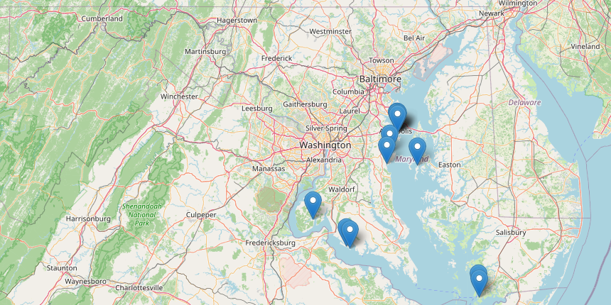
Figure 1: Hydronet water level sensor locations across the Chesapeake Bay region. Figure from Hydronet (Puschnigg 2025).
As shown in Figure 1, Hydronet stations are distributed across multiple Chesapeake Bay locations, including areas near the main bay and connected tributaries. This spatial coverage is important because water levels in the Chesapeake Bay are not uniform across the region. A station near Crisfield, MD, may have a different flooding response than a station farther north in Annapolis, MD. The map supports the need for distributed monitoring by showing why local water-level differences may not be captured by a smaller number of traditional tide gauges.
Background: Coastal Flooding of the Chesapeake Bay
Coastal flooding has become a growing concern in the Chesapeake Bay region, especially as sea level rise increases baseline water levels and makes flooding more likely during high tides. In many places, this flooding happens even without a major storm and is often referred to as tidal flooding or nuisance flooding. While these events may not always cause catastrophic damage, they can still disrupt roads, neighborhoods, and waterfront infrastructure over time. This makes coastal flooding an important issue not only for the communities around the bay but also for scientists studying how water levels change in estuarine systems (Li et al. 2021).
The Chesapeake Bay is especially vulnerable to this kind of flooding because it has many tributaries, irregular shorelines, and low-lying coastal communities. Bukvic and Harrald (2019) show that flooding is not experienced the same way everywhere across the Mid Atlantic. Their study explains that rural communities often face different challenges, with rural areas frequently having fewer resources and less formal support for flood response and adaptation. This makes a localized understanding of flooding especially important, since different communities may have different needs and levels of vulnerability.
Flooding in the Chesapeake Bay is also shaped by physical coastal processes, which is why it connects directly to coastal oceanography. Water levels in estuaries are influenced by tides, sea level rise, and local conditions, and these factors can change how flooding happens from place to place. Lee et al. (2017) found that sea level rise can affect tidal range in Chesapeake and Delaware Bays, showing that rising water doesn’t simply raise water levels by the same amount everywhere. Instead, changes in tidal range can make some locations experience stronger or weaker tidal responses than others. Li et al. (2021) also found that flooding in the Chesapeake Bay is shaped by both rising sea level and changes in estuarine tidal behavior.
Taken together, these studies show why the Chesapeake Bay cannot be monitored as one uniform water body. Sea level rise provides the broader background trend, but tributary shape, shoreline elevation, tidal range, and community vulnerability affect how that trend is experienced locally. This is the reason that local observations matter in coastal oceanography. If flooding varies across locations, observation systems need to capture that variability rather than assuming that one station represents an entire region. That idea helps explain why newer approaches to water level monitoring, including distributed sensor networks, are becoming more important in coastal flood research and management (Tien et al. 2023; Hino et al. 2025).
The Need for Monitoring
Monitoring is an important part of understanding coastal flooding because it shows when flooding happens, how often it occurs, and how water levels change across different places. In the Chesapeake Bay region, this is especially important because flooding is expected to become more common as sea level continues to rise and high tide flooding increases (Li et al. 2020). As flooding changes over time, communities and scientists need accurate observations to track changes and better understand which areas are most at risk.
Monitoring is also necessary because flooding does not happen the same way everywhere. Water levels can vary across tributaries, shorelines, and communities, so one tide gauge may not fully represent flooding in nearby areas. This is important in the Chesapeake Bay, where local geography and estuarine processes can affect how tides and flooding behave across the bay (Lee et al. 2017; Li et al. 2021). Because of this, broad regional observations are useful, but they are not always enough to capture flooding patterns at the scale of individual roads, docks, neighborhoods, or small tributaries.
Another reason monitoring matters is that communities experience flooding differently. Bukvic and Harrald (2019) show that rural and urban communities in the Mid Atlantic often face different challenges, resources, and levels of support when dealing with coastal flooding. This means that having accurate local data can be especially helpful for smaller or more vulnerable communities that may otherwise be overlooked. Better monitoring can support planning, improve awareness, and help communities respond more effectively to repeated flooding events.
Recent research shows that traditional monitoring methods may miss some of the flooding that people actually experience on land. Hino et al. (2025) found that land-based sensors revealed a higher frequency of coastal flooding than tide gauges alone suggested. This finding supports the idea that flood monitoring systems need to capture water levels at the local scale, not only at a few widely spaced stations. For this reason, distributed water level sensor networks are becoming increasingly important because they can provide more detailed observations across different communities and waterways (Tien et al. 2023).
Existing Monitoring Systems
Several systems already exist to monitor coastal flooding and changing water levels. Traditional tide gauges are one of the main tools used to track tides, sea level, and flood conditions over time. These systems are valuable because they provide long-term records and help show that flooding along the U.S. coastline relies on water level records to show that flooding is becoming more common as sea level rises and tidal behavior changes (Li et al. 2020; Li et al. 2021). For this reason, tide gauges remain essential for understanding regional trends and long-term change.
At the same time, traditional monitoring systems also have limitations. One of the main problems is that they are often too spread out to capture flooding at the local scale. In a region like the Chesapeake Bay, where tributaries, shoreline shape, and tidal behavior can vary from place to place, one station may not fully represent nearby communities or waterways (Lee et al. 2017). This doesn’t mean tide gauges are unimportant. Instead, it means that long-term tide gauges are strongest for records and regional trends, while distributed sensors are useful for showing how water levels differ across nearby places during actual flood events.
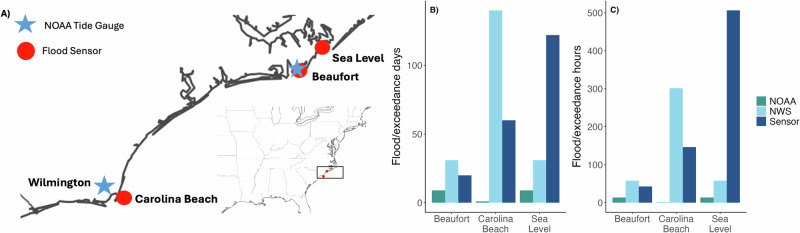
Figure 2: Comparison of flood events detected by land-based sensors and flood estimates based on tide gauge thresholds exceedances. This figure shows that tide-gauge thresholds do not always match flooding observed on land, which supports the need for more localized monitoring systems. Figure from Hino et al. (2025).
Figure 2 helps show one of the main limits of relying only on traditional tide gauges. Hino et al. (2025) found that land-based sensors recorded flooding at frequencies that did not always match NOAA or NWS tide-gauge threshold exceedances. This comparison is useful for this paper because it shows that a regional tide gauge can either miss local flooding or fail to represent the exact conditions people experience on land. Although Hino et al. (2025) focused on North Carolina, the same ideas are relevant to the Chesapeake Bay because both regions include low-lying coastal communities where flooding can vary over short distances.
Hydronet
Hydronet is a distributed water level monitoring network based at the University of Maryland that works to improve water level monitoring across the Chesapeake Bay region. The project focuses on expanding real-time data coverage in high flood risk areas that do not have enough existing monitoring infrastructure (Puschnigg 2025). Supported through the University of Maryland’s Maryland Climate Resilience Network, with additional support committed by the Mid-Atlantic Regional Association Coastal Ocean Observing System (MARACOOS), Hydronet is designed to strengthen coastal resilience and improve flood risk awareness across the broader Chesapeake Bay watershed (Puschnigg 2025). By collecting water level data from multiple locations, Hydronet provides more localized observations of tidal changes and flooding than widely spaced traditional gauges can offer (Puschnigg 2025). This makes it especially useful in a region like the Chesapeake Bay, where tributaries and shoreline communities can experience different flooding patterns. Research has shown that denser local observations can reveal flooding that tide gauges alone may miss, which supports the value of distributed systems like Hydronet (Hino et al. 2025; Tien et al. 2023).
Hydronet is different from a single traditional tide gauge because its value comes from spatial coverage. Instead of only measuring water level at one long-term reference station, a distributed network can place sensors in multiple tributaries, waterfront communities, and flood-prone locations. These sensors can measure changing water levels in near real time, allowing researchers and local partners to compare how different sites respond to the same tide, storm, or wind events. This is especially useful in the Chesapeake Bay because water level behavior can vary across tributaries, narrow waterways, and low-lying communities.
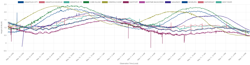
Figure 3: Hydronet water level time series from multiple Chesapeake Bay monitoring stations during May 10 to May 11. The y-axis shows water level height relative to MLLW, and the x-axis shows local observation time. The different colored lines represent different Hydronet stations. Figure from Hydronet (Puschnigg 2025).
Figure 3 provides a direct example of the value of Hydronet data. Even over a relatively short time period, the stations show different water level ranges, timing of peaks, and overall tidal behavior. Some sites reach higher water levels earlier, while others peak later or show smaller changes. This supports the idea that Chesapeake Bay water levels vary across tributaries and shoreline locations. If only one monitoring station were used, these site-to-site differences would be much harder to identify.
Conclusion
Coastal flooding is becoming a more serious issue in the Chesapeake Bay region as sea level rise and changing tidal conditions increase flood risk over time. In this region, flooding doesn’t happen the same way everywhere, which makes local monitoring especially important (Lee et al. 2017; Li et al. 2021). Traditional tide gauges are still valuable because they provide long-term water level records, but they don’t always capture flooding at the smaller scale where people actually experience it (Hino et al. 2025). Hydronet helps address this problem by providing more localized water level observations across Maryland waterways, expanding monitoring coverage in areas that need it most (Puschnigg 2025). Because of this, Hydronet is an important example of how distributed sensor networks can improve understanding of tidal flooding in the Chesapeake Bay and support better flood monitoring for vulnerable communities (Li et al. 2020; Tien et al. 2023).
Overall, Hydronet matters because it adds local detail to the broader regional picture of coastal flooding. As sea level rise continues to increase flood risk in the Chesapeake Bay, distributed water level networks can help researchers and communities better understand where flooding happens, how it differs across tributaries, and which places may need more targeted monitoring or planning.
References
Bukvic, A., & Harrald, J. (2019). Rural versus urban perspective on coastal flooding: The
insights from the U.S. mid-atlantic communities. Climate Risk Management, 23, 7–18.
https://doi.org/10.1016/j.crm.2018.10.004
Hino, M., Anarde, K., Fridell, T., McCune, R., Thelen, T., Farquhar, E., Woodard, P., & Whipple,
A. (2025). Land-based sensors reveal high frequency of coastal flooding.
Communications Earth & Environment, 6(1). https://doi.org/10.1038/s43247-025-02326-w
Lee, S. B., Li, M., & Zhang, F. (2017). Impact of sea level rise on Tidal Range in Chesapeake
and Delaware Bays. Journal of Geophysical Research: Oceans, 122(5), 3917–3938.
https://doi.org/10.1002/2016jc012597
Li, M., Zhang, F., Guo, Y., & Wang, X. (2020). Probabilistic projections of high-tide flooding for
the State of Maryland in the twenty-First Century. Evaluating Climate Change Impacts, 65–86. https://doi.org/10.1201/9781351190831-4
Li, S., Wahl, T., Talke, S. A., Jay, D. A., Orton, P. M., Liang, X., Wang, G., & Liu, L. (2021).
Evolving tides aggravate nuisance flooding along the U.S. coastline. Science Advances, 7(10). https://doi.org/10.1126/sciadv.abe2412
Puschnigg, A. (2025). Hydronet. HYDRONET. https://hydronet.umd.edu/
Tien, I., Lozano, J.-M., & Chavan, A. (2023). Locating real-time water level sensors in coastal
communities to assess flood risk by optimizing across multiple objectives. Communications Earth & Environment, 4(1). https://doi.org/10.1038/s43247-023-00761-1